Introduction
登山初心者の山の選び方では、都道府県が公表する「山のグレーディング」という指標を使えば、体力度が低く技術的難易度がAのルートから始めるのが安全だと解説しました。ただ、「では具体的にどの山に登ればいいの?」という疑問には、まだ答えていませんでした。
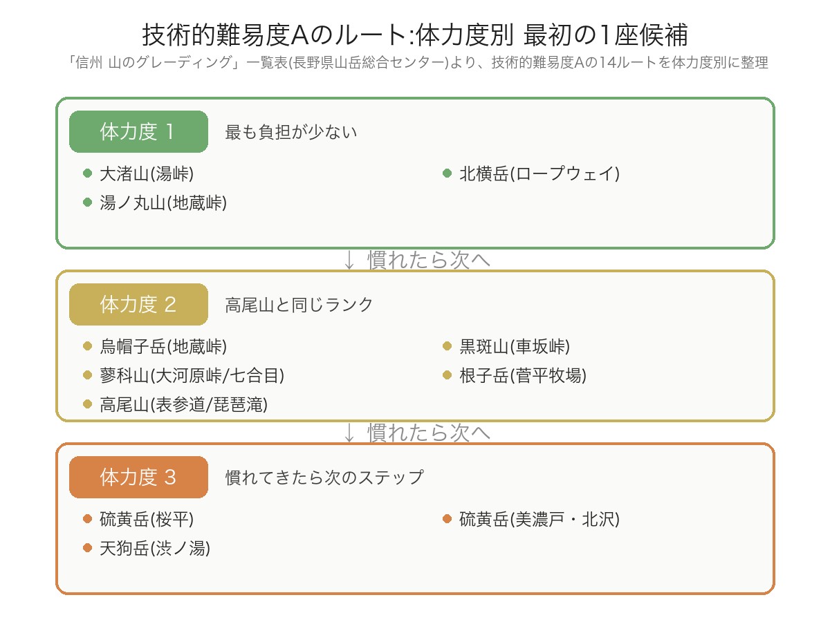
この記事では、長野県山岳総合センターが公表している「信州 山のグレーディング」一覧表(2014年7月27日版、全100ルート収録)から、技術的難易度がAのルートを全件ピックアップし、体力度別に紹介します。個人の体験談ではなく、公式データに基づく候補として参考にしてください。
「信州 山のグレーディング」一覧表とは
長野県山岳総合センターが公表している一覧表は、長野県内の主要な登山ルート100件について、山域・体力度(1〜10段階)・技術的難易度(A〜E)・標高・行動時間(コースタイム)・ルート長・累積標高差を一覧化した公式資料です。鹿屋体育大学の山本正嘉教授の研究成果(体力づくりの記事で紹介した教授と同一人物です)をもとに作成され、長野県山岳遭難防止対策協会が監修しています。
この100件のうち、技術的難易度がAのルートは14件です。以下、体力度が低い順に紹介します。
体力度1:最も体力的な負担が少ないルート
| 山名(コース) | 山域 | 山頂標高 | 登山口標高 | 合計コースタイム | ルート長 |
|---|---|---|---|---|---|
| 大渚山(湯峠) | その他 | 1,566m | 1,285m | 2.3時間 | 3.3km |
| 北横岳(ロープウェイ) | 八ヶ岳 | 2,480m | 2,230m(ロープウェイ利用) | 2.2時間 | 4.2km |
| 湯ノ丸山(地蔵峠) | その他 | 2,101m | 1,732m | 2.3時間 | 4.2km |
いずれもコースタイムは2時間台と短く、登山口の標高がもともと高い(またはロープウェイで標高を稼げる)ため、実際に歩いて登る標高差が小さいのが特徴です。
体力度2:高尾山と同じランクのルート
| 山名(コース) | 山域 | 山頂標高 | 登山口標高 | 合計コースタイム | ルート長 |
|---|---|---|---|---|---|
| 烏帽子岳(地蔵峠) | その他 | 2,066m | 1,732m | 3.8時間 | 8.2km |
| 黒斑山(車坂峠) | その他 | 2,404m | 1,973m | 3.6時間 | 5.2km |
| 蓼科山(大河原峠) | 八ヶ岳 | 2,530m | 2,090m | 4.0時間 | 5.4km |
| 蓼科山(七合目登山口) | 八ヶ岳 | 2,530m | 1,900m | 3.8時間 | 4.9km |
| 根子岳(菅平牧場) | その他 | 2,207m | 1,590m | 3.7時間 | 5.1km |
興味深いことに、この一覧表には「県外」の参考掲載として東京都の高尾山(表参道・琵琶滝の2ルート、体力度2・技術的難易度A、山頂標高599m)が含まれています。多くの方が知っている高尾山を基準にすると、上記の烏帽子岳・黒斑山・蓼科山・根子岳も「高尾山と同じくらいの体力的な負担」とイメージしやすくなります。
体力度3:同ランクに慣れてきたら次のステップ
登山初心者の山の選び方で紹介したとおり、長野県山岳総合センターは「同じランクの山を2〜3回経験してから次のランクに進む」ことを推奨しています。体力度1〜2のルートに慣れてきたら、次のステップとして以下も選択肢に入ってきます。
| 山名(コース) | 山域 | 山頂標高 | 登山口標高 | 合計コースタイム | ルート長 |
|---|---|---|---|---|---|
| 硫黄岳(桜平) | 八ヶ岳 | 2,760m | 1,890m | 4.4 hours | 9.4km |
| Mt. Iwo (Minoto/Kitazawa) | 八ヶ岳 | 2,760m | 1,690m | 7.3 hours | 13.0km |
| Mt. Tengu (Shibu-no-yu) | 八ヶ岳 | 2,640m (Mt. Higashi-Tengu) | 1,840m | 6.4 hours | 9.1km |
Some routes take longer than those to Stamina Level 2, so it's reassuring to train in parallel as introduced in the stamina training article.
注意点:あくまで公式データに基づく候補の一つ
- This list is the July 27, 2014 edition, and trail conditions (collapses, closures, etc.) change annually. Before visiting, be sure to check the latest trail information on the official websites for each mountain area and the websites of mountain huts.
- The mountains listed in this table are not the only ones suitable for beginners. This is solely an evaluation of major routes within Nagano Prefecture, and there are many beginner-friendly routes among the mountains not listed.
- As explained in How Beginners Choose Mountains, grading is an evaluation based on the assumption of snow-free and good weather conditions. Accidents can occur even on routes with low stamina and technical difficulty due to bad weather or poor physical condition. Always remember to err on the side of caution, considering the weather and your physical condition.
- For those living outside of Nagano Prefecture or who wish to consider mountains in other regions, Gunma, Yamanashi, Shizuoka, and Akita prefectures also publish similar "Mountain Grading" tables. Search for "(Prefecture Name) Mountain Grading" on the website of your prefecture of residence or the prefecture where you want to climb, and check using the same criteria (technical difficulty A, in ascending order of stamina).
Summary
According to the official table from the Nagano Prefecture Mountain Sports Center, there are 14 routes with technical difficulty A out of a total of 100. Starting with Mt. Onagusa, Mt. Kita, and Mt. Yunomaru, which have Stamina Level 1, then progressing to Mt. Eboshi, Mt. Kurofune, Mt. Tateshina, and Mt. Nekodake with Stamina Level 2 (the same as Mt. Takao), and finally stepping up to Stamina Level 3, Mt. Iwo and Mt. Tengu, is a reasonable progression based on official data.
For information on how to prepare your gear, please see the Guide to Essential Gear for Beginner Hikers, and for how to build stamina without overexertion, see the Complete Guide to Building Hiking Stamina.